
Free wildfire risk check
Is this property in a wildfire zone?
The fire hazard zone, WUI status, and what it means for the build and the insurance, from state and federal fire data.
Free · No signup · Instant results · All 50 states
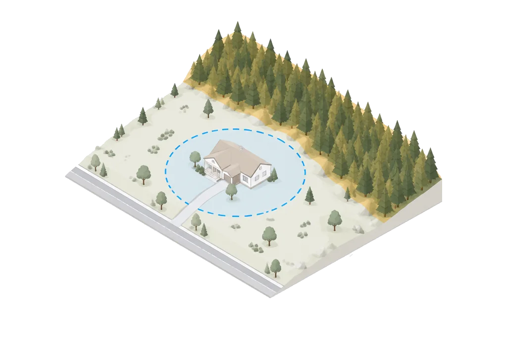
Sample result
The fire story on any address.
Illustrative preview. The live tool renders your address against state fire hazard severity zone maps, WUI boundaries, and historical fire data.
Low wildfire risk. No special fire-related building requirements expected for this location.
In a high wildfire risk zone, fire-resistant materials (Class A roof, non-combustible siding) are typically required, and defensible space clearance of 30–100 ft is mandated.
Insurance impact, mitigation cost estimates, and the building code requirements specific to your zone.
From address to fire risk in seconds.
- 01
Type any U.S. address.
Coverage includes state fire hazard maps and federal wildfire data.
- 02
Get the wildfire risk level.
The parcel is cross-referenced against state fire hazard severity zone maps, Wildland-Urban Interface (WUI) boundaries, and historical fire data.
- 03
See what it means.
Building requirements, defensible space rules, and the insurance implications for that risk level.
Mitigation
Defensible space, zone by zone.
Non-combustible materials only in the immediate perimeter around the structure.
Fire-resistant landscaping that keeps flames from reaching the walls.
Thinned vegetation and trimmed trees. Initial clearing runs $2,000–$10,000; maintenance $500–$2,000 a year.
Rebuild cost
What it actually costs to build to fire code.
Delta costs against conventional construction for the six components that matter in a WUI rebuild. Insurance discounts and IBHS Wildfire Prepared Home certification recover most of the spend inside five years.
| Component | Requirement | Delta cost | Insurance impact |
|---|---|---|---|
| Class A roof | Metal, tile, or asphalt-fiberglass shingle rated Class A per ASTM E108 | +$5k – $15k | 10–20% premium reduction typical |
| Ignition-resistant siding | Fiber cement, stucco, or ignition-resistant treated wood | +$8k – $25k | 5–10% additional reduction |
| Ember-resistant vents | 1/8″ mesh or intumescent vents on eaves and crawlspaces | +$2k – $5k | Required by CA Chapter 7A |
| Tempered dual-pane windows | Dual-pane with one tempered pane on exposed elevations | +$3k – $10k | Modest discount; safety benefit |
| Defensible space clearing | Initial clearing of Zones 0/1/2 (0–100 ft around the structure) | $2k – $10k | Often required for insurance eligibility at all |
| Defensible space maintenance | Annual vegetation management to preserve Zones 0/1/2 | $500 – $3k / yr | Compounds insurance eligibility year over year |
Delta costs are typical for a 2,000 sq ft single-family rebuild in a CA-rated Chapter 7A jurisdiction; the range widens on custom builds and coastal exposures. IBHS Wildfire Prepared Home certification stacks with individual-component discounts. Certified homes routinely see 20–40% total premium reductions versus conventional construction in the same WUI zone.
The exposure
Forty-six million homes sit in the Wildland-Urban Interface.
Where development meets wildland vegetation, the building code gets stricter, insurance gets dearer, and vegetation management becomes a standing obligation.
Before you decide.
How do I check if my property is in a wildfire zone?
Enter your address above for a free instant wildfire risk check. Buildability™ cross-references state fire hazard severity zone maps, Wildland-Urban Interface (WUI) boundaries, and historical fire data to determine your risk level. Results include building requirements and insurance implications.
What is a Fire Hazard Severity Zone?
Fire Hazard Severity Zones (FHSZ) are designated areas that indicate the likelihood of wildfire exposure. Zones are rated as Moderate, High, or Very High. Properties in High or Very High zones typically require fire-resistant roofing, siding, windows, and defensible space clearance of 30-100 feet.
Does wildfire risk affect insurance costs?
Yes. Properties in high wildfire risk zones face higher insurance premiums and may have difficulty obtaining standard coverage. Some insurers have pulled out of high-risk areas entirely. The full Buildability™ report includes insurance impact analysis and mitigation recommendations that can help reduce premiums.
What building requirements apply in wildfire zones?
In High and Very High fire zones, requirements typically include Class A fire-rated roofing, non-combustible or ignition-resistant exterior materials, tempered glass windows, enclosed eaves, and 5-foot non-combustible zones around structures. Defensible space of 30-100 feet of cleared vegetation is also required.
What is the Wildland-Urban Interface (WUI)?
The WUI is the zone where human development meets or intermixes with wildland vegetation. Over 46 million homes in the U.S. are in the WUI. Properties in the WUI face elevated wildfire risk and may have stricter building codes, higher insurance costs, and vegetation management requirements.
Can I still get insurance in a high wildfire risk area?
It is increasingly difficult. State Farm, Allstate, and other major insurers have reduced coverage in high-risk areas, particularly in California. Options include the FAIR Plan (California), state-backed insurers of last resort, or specialized carriers. Premiums can be 3-10x higher than standard areas. Mitigation improvements can help.
What is defensible space and how much does it cost?
Defensible space is the area around a structure where vegetation and materials are modified to reduce fire risk. Zone 1 (0-5 feet): non-combustible materials. Zone 2 (5-30 feet): fire-resistant landscaping. Zone 3 (30-100 feet): reduced fuel load. Initial clearing costs $2,000-$10,000; annual maintenance $500-$2,000.
How does wildfire risk affect property value?
High wildfire risk reduces property values by 5-15% on average. Properties that have experienced nearby fires see 10-20% value declines. Insurance unavailability is the biggest factor: buyers struggle to close when they cannot obtain coverage. Mitigation improvements can partially offset value impacts.
Which states have the highest wildfire risk?
California, Colorado, Oregon, Washington, Montana, Idaho, Arizona, and New Mexico have the highest wildfire exposure. California alone accounts for over 40% of U.S. wildfire risk. Climate change is expanding wildfire zones into areas historically considered low risk, including parts of the Southeast and Northeast.
How do I reduce wildfire risk on my property?
Key mitigation steps: (1) Create and maintain defensible space. (2) Install Class A fire-rated roofing. (3) Use non-combustible siding and decking. (4) Install ember-resistant vents. (5) Clear gutters and remove dead vegetation. (6) Keep trees trimmed 10+ feet from structures. These improvements can reduce insurance costs and improve insurability.
Want the whole picture?
Nine weighted factors. Wildfire, flood, zoning, seismic, soil, radon, utilities, terrain, and lot geometry, for any U.S. address.
Type the address. Looking is free.
Twenty seconds from now you will know whether fire is a factor for this lot.
Free to score · Full report $99 · All 50 states